This story and many more are available in the book ALABAMA FOOTPRINTS Exploration: Lost & Forgotten Stories (Volume 1)
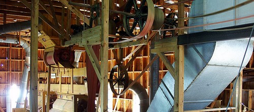
The First Cotton Gin in Alabama
In 1797 a ferry was established by Samuel Mims across the Alabama (River), and on by Hollinger, an old resident among the Indians, across the Tombeckbee.(Tombigbee) The route of travel crossed the Island called Nannahubba below the cut-off.
But a change for the settlers under Spanish rule was near at hand. Arrangements were made by the United States Government to have the line of latitute 31° established.
Col. Andrew Elliott
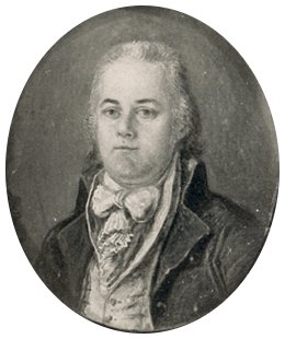
In 1709, March 29, the Spaniards evacuated their fort on the Mississippi, and Colonel Andrew Elliott, one of the commissioners to mark this boundary line between Spanish and United States territory, marched his troops and corps of wood-men and surveyors to a dense swamp on the east of the Mississippi, where it was ascertained that the line left the river.
Sir William Dunbar
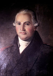
He was soon joined by Major Minor and Sir William Dunbar, Spanish commissioners. Spain also furnished troops. The advance along the line resembled the movement of an army. The trees were blazed along the line, and mounds of earth thrown up at the end of each mile. This line struck the Mobile river “six miles’” Pickett says, ten miles it no appears to be, below the union of the two rivers. It was now April 1799.
Unlock all Alabama Pioneers stories
Alabama Pioneers members see thousands of stories, biographies and nostalgic items like this everyday.
Become an Alabama Pioneers Patron
Become a true Alabama Pioneers Patron – Get the Alabama Pioneers Patron APP
Only Patrons can comment or chat.
Join our Alabama Pioneers Patron Community!’
See how to Become an Alabama Pioneers Patron
Chattahoochee river
The surveyors overcame the difficulties in crossing the rivers and swamps, and passed beyond the Tensaw. Passing through the Creek lands the party met with obstacles and opposition from the Indians, and also from the Spaniards. They marked the line only as far as the Chattahoochee, but the surveyors passed across to the St. Mary’s and in February of 1800 established the point on that river of the line of 31° in the presence of Colonel Elliott and Major Miner. This spot was marked by a large earth mound. The United States had now, after the death of Washington, early in 1800, a recognized southern boundary line……..
Old St. Stephens site
In 1801 a treaty was made with the Choctaws, by which a tract of land was acquired, extending some distance north from St. Stephens. The Choctaws claimed east of the Tombeckbee to the water-shed or dividing ridge. The Creeks did not acknowledge their rights, and at the treaty in 1802 one of their chiefs, the Mad Wolf, is reported to have said, “the people of Tombigby have put over their cattle in the fork, on the Alabama hunting grounds, and have gone a great way on our lands. I want them put back. We all know they are Americans.”
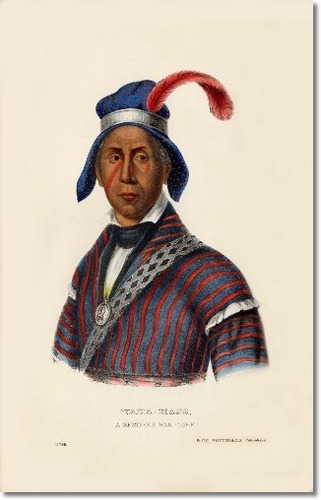
YAHA-HAJO (Mad Wolf) was the second principal war chief of the Seminole nation and had been among the seven chiefs selected to inspect the western lands
From this speech it is evident that at this time there were whites occupying lands east of the Tombeckbee. (Tomgbigbee)
In the same year a trading house was established at St. Stephens, designed especially for the Choctaw Indians. This establishment was called a factory. Joseph Chambers was appointed Superintendent and Thomas H. Williams, both from North Carolina, Assistant. The latter became afterward Secretary of the Territory, Collector of the port of New Orleans, and United States Senator from Mississippi. George S. Gaines of Virginia, then residing in Tennessee, was afterward appointed Assistant, and came to St. Stephens in the spring of 1805.
At that time “the parsonage of the old Spanish church was used as a skin-house,” the block house being used for a government store room. In 1807 Gaines became what was called “principal factor,’ having an assistant, a “skin-man” or fur and hide tender, and an interpreter. This tender of furs and hides examined them carefully during the summer, sorted them, and in the fall packed them in bales for shipment to Philadelphia.
The articles brought for sale or exchange by the Choctaws, were furs and peltries of various kinds, bears’ oil, honey, beeswax, bacon, tobacco, and ground peas. Those in 1809 amounted in value to more than seven thousand dollars. To avoid the payment of Spanish duties at Mobile the Government arranged a line for conveying gods to this ware-house and trading post down the Ohio river, up the Tennessee to a point called Colbert’s Ferry, then by pack horses along a horse path through the Chickasaws, to Peachland’s,ii upon the Tombeckbee, then by boats to St. Stephens.
In 1802, also, the first cotton gin, in the region now Alabama, was erected by Lyons and Bennett of Georgia, for Abram Mordecai, a Jew and an Indian trader, at Weatherford’s race track on the Alabama river. The materials for the work, tools and machinery, were brought from Georgia on pack horses. Cotton from this gin was taken in the same summer to Augusta, Georgia. This Mordecai carried on a large trade with the Indians, sending to Mobile and to New Orleans his furs and hickory nut oil in boats, and transporting goods to and from Pensacola and Augusta on pack horses. His gin house was afterward burned by the Indians in consequence of intrigues in which he became involved with a handsome married squaw.
Major Levi Colbert, the famous Chickasaw Indian chief, was another conspicuous figure in these early times. One of his wives, Seletia Colbert, is said to have lived at Colbert’s ferry, where the trace road crossed the Tennessee. The other wife lived at what is now known as the French farm, not far from Okolona, in Monroe County. It was near this point that one branch of the trace road turned south through the prairie and the other northwest to Pontotoc. It is about eighty miles from Cotton Gin Port on the Tombigbee to Colbert’s ferry on the Tennessee, and even a less distance “as the crow flies.” (Publications of the Mississippi Historical Society, Volume 7 edited by Franklin Lafayette Riley)i McIntosh’s Bluff played an important part in Alabama’s history including the place were Vice-President Aaron Burr was captured.
ii At or near Waverly, where the Oktibbeha river unites with the Tombigbee, was Peachland’s, the place mentioned in the quotation from Pickett’s history. It was here that Gaines unloaded his produce carried all the way from Colbert’s ferry on the Tennessee by way of Cotton Gin Port on pack horses and mules, and reloaded it on rafts or boats for St. Stephens. Peachland’s was a famous place in early frontier days. John Peachland, or Jack Pitchlyn, as he was often called, and his two sons, Peter and Jack, owned all that section of Lowndes county and part of Clay. Jack Pitchlyn was a half-breed, the son of an Englishman. He was always a faithful and influential friend of both the Indian and the white man. His home is time and again mentioned in the early chronicles, and he is also frequently named as a participant in treaties and other important transactions. He had a commission as United States interpreter for the Choctaws, and was sub-agent. His home seems to have been once a famous stopping place for travelers. He was buried at Waverly, just across Tibbee in Chickasaw territory, that being the boundary between the Chickasaws and Choctaws. His widow and descendants made several pilgrimages to his grave after the removal of his tribe to Indian Territory, and they finally removed his bones there. (Publications of the Mississippi Historical Society, Volume 7 edited by Franklin Lafayette Riley)
SOURCE
- The Great Southeast or Clarke County and its Surroundings, pub. 1882 by Rev. T. H. Ball)
ALABAMA FOOTPRINTS Pioneers: Lost & Forgotten Stories – Stories include:
- The Yazoo land fraud;
- daily life as an Alabama pioneer;
- the capture and arrest of Vice-president Aaron Burr;
- the early life of William Barrett Travis,
- hero of the Alamo;
- Description of Native Americans of early Alabama including the visit by Tecumseh;
- Treaties and building the first roads in Alabama.
See all books by Donna R. Causey
ALABAMA FOOTPRINTS – Volume I – IV: Four Volumes in One (Volume 1-4)


The name I have seen in many other places was Andrew Ellicott, not Elliott.
Thank you for the correction. It must have been a typo where I found the information.
Great History of Early Alabama territory. Would love to have a copy of this book. Thanks for posting. Enjoyed the reading and the History.
Maybe Andrew Ellicott was the commissioner.
See https://en.m.wikipedia.org/wiki/Andrew_Ellicott
Ernest Fite, PE & LS
In Buck’s Al. There is a large stone marking the line, it’s called Ellicott stone.He was from Bucks,PA and I have often wondered if the spot on Hwy 43n was named after him. There’s an Alabama Power Generating plant there and that about it.
What about Eli Whitney ??
They will be after any eli Whitney tributes next.
LOL Whitney just improved on it.
Thanks for sharing
TY!